 Start
Start: Aiken, SC
End: Midland, TX
Est. Length: 1,200 miles (Augusta to Houston)
Benefits: Homeland Security, Economic Development, Environmental/Fuel, Population Centers, Existing Highways
Connecting: SC: Aiken.
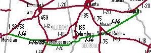
GA: Augusta, Macon/Warner Robins, Columbus.
AL: Montgomery.
MS: Meridian, Hattiesburg, Natchez.
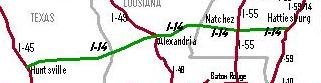
LA: Alexandria.
TX: Jasper, Houston (at Huntsville), College Station, Killeen, San Angelo, Midland
Intersections: I-20 Aiken, SC; I-30, Augusta, GA; I-16, Macon/Warner Robins, GA; I-75, Macon/Warner Robins, GA; I-22, Columbus, GA (
proposed); I-81, Columbus, GA (
proposed); I-314 Montgomery, AL, I-65 Montgomery, I-85 Montgomery (merge), I-85 Split, Selma, AL; I-7, Fruitdale, AL; I-59, Laurel, MS, I-55; Brookhaven, MS; I-11, Natchez, MS; I-49, Alexandria, LA; I-45, Huntsville, TX, I-35, Temple, TX; I-20, Midland, TX.
Description: A new Interstate highway from Augusta, Georgia to Natchez, Mississippi has already been funded for study. This highway has broad appeal and promises economic growth to those areas of the deep south left off of the original Interstate highway systems. By beginning the highway in Aiken, South Carolina, and utilizing a segment of I-520, Interstate-14 can extend it’s ultimate route and incorporate a larger portion of metro Augusta. An intersection with the proposed Interstate-3 (see I-30) would form a large loop highway around Fort Gordon, Georgia. I-14 will ultimately connect Aiken, South Carolina/Augusta, Georgia on the east with Houston, Texas in the west.
Many Columbus, Georgia area leaders are supporting the highway and some are further proposing that the highway run through the southern portions of metro Columbus. By doing this, the proposed I-14 would merge with and form the southern portion of the proposed Benning Beltway. Southern routes through Greater Augusta, Greater Macon, Greater Columbus and Greater Montgomery would also provide an important link between military bases – Maxwell, Benning, Robins and Gordon.
Funding for studying an Interstate-85 extension west of Montgomery, Alabama has recently been approved. A portion of Interstate-14 might also merge with all or parts of the extension of I-85 west of Montgomery, Alabama and form a large section of the Interstate through western Alabama as it dissects a significant portion of Alabama between I-59/20 to its north and I-65 to the south.
The route through western Alabama suggests an intersection with I-20/59 east of Meridian, Mississippi. A merger there would co-route with I-59 to south of Hattiesburg, Mississippi where I-14 would split to continue a western route.
The long-range extension of the new Interstate-14 might include a western route from Natchez, Mississippi to Alexandria, Louisiana and into Texas terminating at I-45 north of Houston at Huntsville, Texas. As discussed in a later installment, I-85 might then split with I-14 west of Montgomery, to take a southern route to coastal Mississippi at Biloxi.
UPDATE: This post has been updated to include I-14 extension plans in Texas by the
Gulf Coast Strategic Highway Coalition. Texas officials are promoting the highway, which is already under development in that state, as the "Forts to Ports" highway. Though originally proposed by Georgia and Alabama officials, the highway is currently not in progress in those states.
In Georgia, the original route for I-14 took on the nickname of "
Fall Line Freeway" for it's course along the geological 'fall-line' from Augusta, GA to Columbus, GA. However, the freeway plan was downgraded to a 'developmental' highway as part of the
Governors Road Improvement Program. The portion of the highway through Columbus known as the JR Allen Parkway is currently the only interstate-grade portion outside Texas. Because of development that has occurred in metro Columbus around the parkway, this proposal, however, suggests a southern route around the city to open lands for additional manufacturing development and better connect Fort Benning, GA to other military bases along the "Forts to Ports" route.
Additional I-14 posts:
US 190 in Texas to become new Interstate 14
Gulf Coast Strategic Highway


 The next southern leg is the one from Texarkana to Fort Smith, AR - a 200-mile stretch estimated estimated to cost $3 billion. A short leg just south of Fort Smith to Alma, AR has already been designated as I-49. Though short, the segment has already sparked development at Chaffee Crossing near Fort Smith, as discussed in this article.